Geomorphic Investigation of Tidal Inlets: Applications in Coastal Engineering U.S. Army Engineer Research and Development Center Coastal and Hydraulics Laboratory
Quantify morphologic changes at tidal inlets and associated navigational channels using remote sensing methods and numerical simulations. The project includes case studies at federally maintained inlets as well as the production of remote sensing and modeling tools that can be applied to all tidal inlets and navigational channels. Coupled circulation and wave transformation models were applied to predict tide and wave generated currents on the inner continental shelf, at tidal inlets, and in navigational channels. Model validation was performed by comparing model output to measured water surface elevations and current velocity data inside the bay. Calculated sand transport rates were compared to theoretical estimates of sediment transport calculated by the CERC Formula. Shoal development and relative movement of morphological features were reproduced in the model simulations..
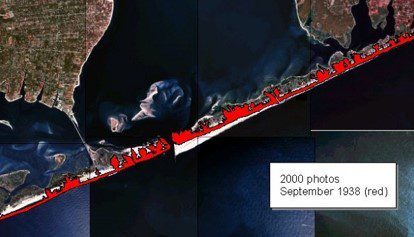
Comparison of inlet configuration over a 62-year period from remote sensing and GIS methods applied at Shinnecock Inlet, Long Island, NY.
Client:
-
U.S. Army Engineer Research Development Center (ERDC), Coastal and Hydraulics Laboratory (CHL)
Project Duration:
- 2001-2007
Team Members:
- Dr. Gary Zarillo
Services Provided:
- Remote Sensing
- Circulation and Wave Transportation Modeling
- Sediment Transport Calculation