CCAFS Infrastructure Survey and GIS Integration
Applied Ecology, Inc. provided GIS database management, data conversion and integration into GIS, quality assurance, and database tool development of survey data of all above ground infrastructure for the Cape Canaveral Airforce Station (CCAFS). The survey includes water, wastewater, electric, stormwater, gas, fuel systems, buildings, antennas/towers, pavement, among others. The project took place in two phases, the start-up and initial workflow validation phase and the subsequent data collection phase. Applied Ecology dedicated significant effort upfront to plan the field data acquisition, develop the appropriate custom tools to more efficiently process datasets, and conduct a pilot test of the workflow and toolsets to validate and perform any necessary corrections to the data collection and processing workflow.
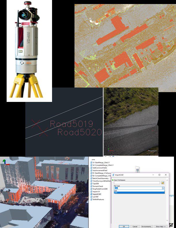
Most of the survey data was collected by the survey team using a Riegl VZ-400 3D laser scanner. This data was provided to Applied Ecology in AutoCAD format. A small amount of data was collected by more traditional survey methods and provided in CSV format files. We created script tools to batch import CAD files and CSV files into a temporary geodatabase. The feature data in the temporary geodatabase was then combined with the existing feature data using a series of custom script tools that we developed in-house. The use of custom GIS tools greatly increased efficiency in data processing and integration, reducing the project timeline and cost significantly.
Client:
- Oneida Total Integrated Enterprises (OTIE) for USAF 45th Space Wing
- Jason Kelley (Assistant Program Manager)
Project Duration:
- 2016 – 2018
Team Members:
- Dr. Claudia Listopad
- William Paton
- Kayleigh Douglass
- Danielle Huffner
Services Provided:
- GIS tool development
- GIS geodatabase management
- Mapping,
- Data validation and topology checks
- QA/QC survey data using GIS
- Creation of detailed Map Books
structures mapped
types of features
square acres mapped
individual terrestrial LiDAR Scans
CCAFS Data Collection and Importation.
The following tasks defined Phase 1:
- Project Startup, mobilization of crew and equipment
- Initial equipment (hardware and software) onsite setup
- Acquired the existing US Air Force SDSFIE geodatabase
- Acquired relevant background layers
- Determined and added additional fields that would help manage the project effort
- Cataloged the existing geospatial datasets
- Prioritized data collection for the pilot test area by establishing a gridded work area
- Established a Workflow SOP (Standard Operating Procedure)
- Created a Map Book of existing data for each of 11 Work Areas to guide the survey team field effort
- Coordinated with the data collection staff on pilot area data collection and processing methodology
- Imported data collected per established methodology and quality assured against high resolution imagery, previously available datasets, and other guidelines
- Reported deficiencies in incoming data to survey team using maps of missing or incorrect features
- Re-evaluated the workflow and made process improvements, including the development of additional geoprocessing custom tools
- Utilized a coordinated project management approach to plan and refine activities between the survey and GIS team
The project smoothly transitioned into the second phase, the Ongoing Data Collection, after the data from the Pilot test area was collected, processed and the workflow validated and refined. This allowed the project team to have an efficient and validated SOP for the remainder of the project duration and be able to complete the survey tasks and data management of the GIS data on-time and within budget. This second phase included the following tasks:
- Coordinated gridded data collection and workflow weekly
- Created updated detailed Map Books for data collection of current gridded work area
- Imported the collected data into the appropriate SDSFIE database layer
- QA/QC of the GPS data provided by the survey team
- Reported deficiencies in incoming data to the survey team
- Performed an internal review for each of the 11 work areas with the team
- Performed a review of the feature data for each of the 11 work areas with the client for acceptance
Applied Ecology understands the complexity of managing large datasets and incoming data from multiple groups. To minimize manual validation of extensive datasets, particularly under severe time constraints, we created script tools to replace existing features in the database with the new surveyed location. Attribute information was retained from previously existing features and applied to the newly surveyed feature locations. Creating such tools greatly improved accuracy and repeatability while reducing labor needs.