Combining Geological and Numerical Models to Assess Sand Resources on the Inner Continental Shelf of Northeast Florida
A geological model of continental shelf sand ridges is combined with a numerical modeling system designed for shallow marine physical processes to assess the potential for recovering beach quality sand. The shelf sand ridge geological model includes a coarsening upward sequence beginning with silts, clay and silty fine sand grading upward into relatively coarse sands having minimal silt and clay fraction. The upper meter of the sequence includes a clean cross-bedded sand unit that is reworked by episodic storms and waves on the inner to mid-continental shelf. Results of a numerical model investigation of modern sand ridges on the inner continental shelf of northeast Florida are consistent with the elements of the geological model. Sand ridge crests at relatively shallow depth activated by passing storms are predicted to be subject to topographic changes of up to 1-m consisting of both deposition and erosion. It is concluded that numerical modeling combined with the appropriate geological modeling can be applied as a tool for identifying potential sand and gravel deposits on the inner continental shelf.
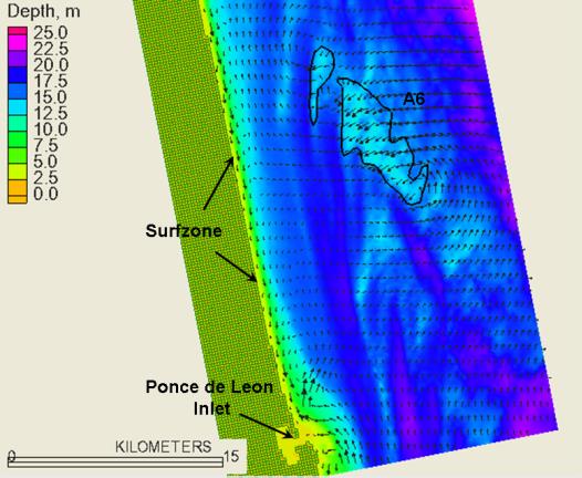
Predicted sand transport patterns during a potion of Hurricane Floyd.
Client:
- U.S. Minerals Management Service
Project Duration:
- 2009
Team Members:
- Dr. Gary Zarillo
Services Provided:
- Geological Modeling
- Numeric Modeling
- Sand Source Assessment