Database Design, Inventory, and GIS Web Application Development for the City of Indian Harbour Beach
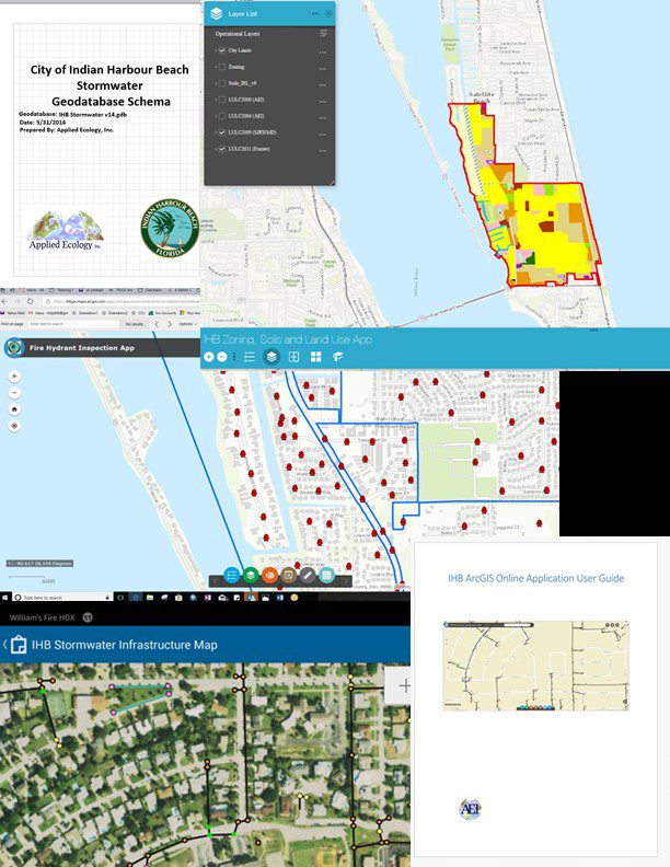
Applied Ecology, Inc. has been involved in the development and maintenance of the City’s GIS data since 2009. Initially, we performed a citywide conversion of hardcopy and CAD Stormwater Inventory Data to a Geospatial database. Additionally, AEI developed custom drainage basins and corresponding loadings according to newly released FDEP model for the Banana River TMDL. A portion of this project also allowed the previously existing Water Quality Masterplan to be revised to reflect the new pollutant loading data, new methodology for the model implementation, and newly updated GIS-based maps. Applied Ecology, Inc. also provided additional geospatial services, such as mapping, spatial analyses and reporting.
More recently, the following services have been performed:
- ArcGIS Online (AGOL) Organizational setup, including users and permissions
Development of a custom geodatabase schema to allow expansion of the current stormwater inventory for future inspection and maintenance efforts, and to better accommodate the mapping and application development tasks - Development of an ArcGIS Online Stormwater Inventory Map and Application
- Zoning and land use maps
- Development of Water Distribution layers and an AGOL map
- Development of an ArcGIS Online Hydrant Maintenance Inspection App
- Development of a Hurricane Debris Cleanup Progress map
- Setup for field data collection using the ESRI Data Collector mobile application
- Training (onsite) on mobile field data collection using the ESRI Data Collector iOS application
City of Indian Harbour Beach GIS program implementation (Infrastructure Life Cycle).
Client:
- City of Indian Harbour Beach
- Mark Ryan (City Manager)
Project Duration:
- 2009 – 2017
Team Members:
- Dr. Claudia Listopad
- William Paton
- Kayleigh Douglass
Services Provided:
- CAD to GIS geodatabase data conversion
- Data development
- GIS geodatabase schema development and population
- Development of AGOL web maps and applications
- Training