Harmful Algal Bloom Remote Sensing in the Brevard County Portion of the Indian River Lagoon and its Tributaries
In 2021, Applied Ecology and Brevard County Natural Resources Management Department (BCNRMD) submitted a proposal that was awarded an innovative technologies grant from the Florida Department of Environmental Protection (FDEP) to address Harmful Algal Blooms (HAB) in the Indian River Lagoon (IRL). With increasing HAB activity in the IRL, the proposal successfully demonstrated that understanding key HAB triggers, life cycles, hotspots of activity, and movement through real-time monitoring was important for adaptive management of the estuary and its watershed.
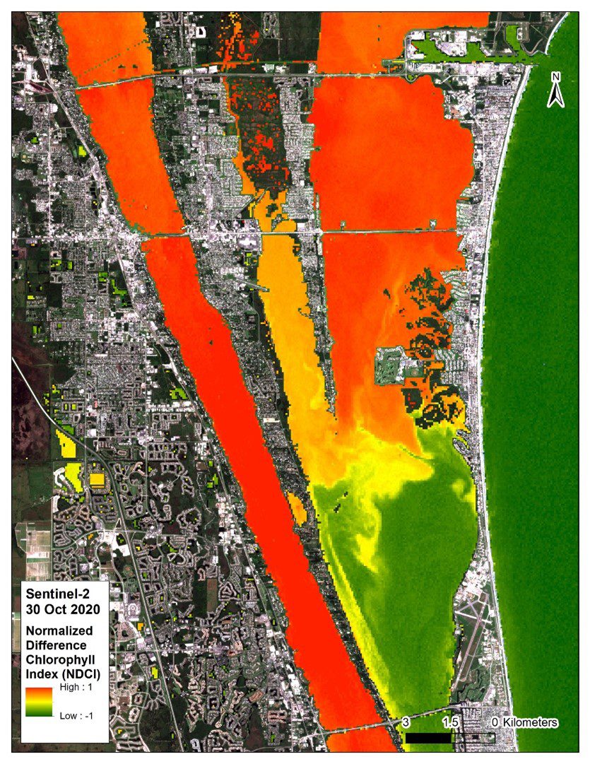
The goal of the innovative HAB Remote Sensing project was to develop a comprehensive, cost-effective approach at capturing and manipulating remote sensing spectral data to identify and create HAB variables for analysis over time and space. The initial grant was used to develop methodologies for processing the European Space Agency (ESA) Sentinel-2 and Sentinel-3 satellite data, to eliminate atmospheric and water column interferences, and improve the accuracy of ChlA estimates using the NDCI. Once a method was developed, AEI tested the methodology using ground-truthed data and started generating weekly HAB updates for BCNRMD to share through educational media and presentations (Figure 1).
To verify the ChlA estimated via the processed satellite data, AEI coordinated hyperspectral field data collection events to coincide with the St Johns River Water Management District (SJRWMD) regular monthly surface water sampling, enabling a comparison of the grab samples with the spectral imagery estimate results. AEI worked alongside SJRWMD field personnel to collect high spatial resolution hyperspectral data using an American-made Harris Aerial Carrier HX8 UAS (drone) equipped with a BaySpec OCI-F hyperspectral camera or a handheld OceanOptics FLAME VIS-NIR spectrometer. These denser spatial and spectral data were used to further refine the method, identify unique spectral features of various HAB species, and detect water column or benthic interferences that may confound results.
After refining the methodology, AEI developed three bloom indices as variables to measure the intensity, duration, and severity of blooms that can be compared over time and space to understand internal and external drivers. AEI is applying the HAB indices to investigate how weather conditions, fish kills, and muck presence may impact HAB activity to guide management priorities. Links to the scientific journal article that was published from this research and the final grant report are below.
Read the full report from the Florida Department of Environmental Protection here.
Read our article published in 2023 for the Florida Scientist here.

